About 2.5 miles NNE of the Lion’s Rump, False Point lies between the two entrances of the Mahanadi River and has been reported to be a good radar target up to 17 miles.
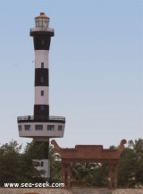
The lighthouse on the point is shown from a white round masonry tower with red bands; the lighthouse is difficult to see if there is a heat haze because it has a light-colored top and there is no background, so care is necessary when navigating in the vicinity of False Point.
The point derives its name from the circumstance that vessels proceeding up the Bay of Bengal frequently mistook it for Point Palmyras, less than a degree farther north.
It is a low headland with a lighthouse located 2 km inland from the point.
During January through March, fog may occasionally obscure the light or cause it to show a deep red color. Frequent soundings should be taken and depths should not be shoaled to less than 20.1m.
During the Northeast Monsoon or with NE winds, the current in the vicinity of False Point generally sets to the W.
From the end of June to the end of November, there is little or no flood or W current off False Point, except at spring tides; a strong outset is experienced from the rivers during freshets.
Off False Bay the flood sets to the NW to N and the ebb sets SW, each at a velocity of about 1 knot. The velocity is greatly influenced by the prevailing winds. The tidal current, together with the coastal current during the Southwest Monsoon, sometimes attains a velocity of 4 knots.
A long tongue of land extends about 3.8 miles NE from False Point and almost meets and sometimes joins the S extremity of Nurrea Banga Nassi, a low grass-covered narrow island about 5.8 miles long. A large stone building, with a banyan tree close by, stands on the W side of the island.
A drying shifting sand spit extends N and W from the N end of Nurrea Banga Nassi.
False Point Anchorage (20°28'N., 86°47'E.) lies in the bay W of the N part of Nurrea Banga Nassi.
The outer anchorage, about 1 mile N of the N extremity of Nurrea Banga Nassi, has a depth of about 7.9m. A depth of 10m exists about 1 mile farther NE. The holding ground is fairly good, but a heavy swell is experienced. Anchorage is not recommended.
Small vessels can anchor in a depression about 1.5 miles long which lies W of the N part of Nurrea Banga Nassi, but local knowledge is necessary. Anchorage within the bay is safe, but the depths are shallow because of silting.
Caution: With strong S winds, the flood sets toward the coast in the vicinity of Satbaia Sandhill about 15 miles N of the N end of Nurrea Banga Nassi. Vessels approaching from the N must guard against this current.
With a strong flood it is advisable to approach the anchorage on a S course. Such a current is noticeable by the rapid drift of the vessels to the N. Stemming the current by turning the vessel to port, to the E or NE, from a S course is advisable before anchoring.
Vessels attempting to turn to starboard, or to the SW and NW, have been swept rapidly to the W and have grounded on the shoals extending from Temple Point


")