Fair Channel Bank (1°33'N., 103°03'E.) consists of two narrow ridges, with depths of less than 18.3m and about 3 miles apart, lying almost parallel with the coast. The bank extends about 22 miles NW from a position about 14 miles WNW of Pulau Kukup (1°19'N., 103°25'E.).
A wreck, with a swept depth of 25.5m, lies about 20 miles WNW of Pulau Kukup and a wreck, with a depth of 23m, lies about 10 miles WNW of the same islet. A long narrow shoal, about 8 miles long in a NW-SE direction, with a least depth of 9.1m, lies with its SE end about 12 miles W of Pulau Kukup. Southwest of Long Bank are numerous similar banks lying parallel with it, extending to within a short distance of the banks fringing the Sumatera side of the strait. An obstruction at the NW extremity of Long Bank is marked by an lighted buoy.
Pulau Pisang (English: Banana island) is a small island located off the Western coast of the Malaysian state of Johor. It is about 12 km from the town of Pontian Kecil and 5 km from Benut town. It is the siteof Pisang Lighthouse guiding ships into the western entrance of the Singapore ...
Karimun Kecil or Little Karimun, separated from the NE side of Great Karimun by a deep channel about 0.5 mile wide, is a bold island, 377m high. In the NW approach to the channel between Great Karimun and Little Karimun are two islets, Nangoi, 39m high, about 1.2 miles W of the ...
The Sungai Benut, entered about 8 miles N of Pulau Pisang, is the largest river along this part of the coast. Only small vessels with local knowledge can be accommodated.
Assan and Mudu, rocky and thickly-overgrown islands, 83 and 65m high, respectively, lie about 1.2 miles off the NW side of Great Karimun. Sajuda, an above-water rock, lies 0.5 mile N of Assan and Seal Rock lies about 0.5 mile NE of Sajuda. Tokong Belanda, a low rock, lies about ...
Bukit Banang, 470m high, is the summit of a range of rolling hills which terminates at Tanjong Seginting. Four radio masts stand on its summit. Several bright white lights, visible for a considerable distance, are sometimes shown near the radio masts. A light is reported to ...


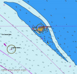


 Fair Channel Bank (1°33'N., 103°03'E.) consists of two narrow ridges, with depths of less than 18.3m and about 3 miles apart, lying almost parallel with the coast. The bank extends about 22 miles NW from a position about 14 miles WNW of Pulau Kukup (1°19'N., 103°25'E.).