- Your comments are welcome - If you would like to add your own report on a marina, harbour, beach or anchorage please click on the "Edit" tab above, delete this text and type your comments. Digital photos are also very welcome using the "photo" link in the left menu. - Regards - The Webmaster
Access to the Harbour is restricted to High Water + or - 3 hrs for
vessels drawing 1.5m. The Duver Marina is the main mooring area
for visiting yachtsmen. Dredged to a depth of 2m MLWS there are approximately
140 visitor berths and a small number of permanent berths. On ...
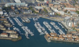
375 berthsMax LOA: 90m Fuel (petrol, diesel) available at nearby Hythe Marina Village and Port Hamble Marina Boat lifting and storage ashore available at nearby Shamrock Quay, Hythe Marina Village and Hamble Point Marina Laundry facilitiesBars and RestaurantsWiFi