During the NE monsoon we can anchor in Balken Bay or Meulingge bay, in depths of from 14,6 to 16,5 m. In the Southwest Monsoon there is a considerable swell and sea.
Pulau Nasi (Peunasoe or Aceh island), nearly joins the SE point of Pulau Breueh, being separated by Aroih Lam Puyang. The coast line is rocky in places with sandy beaches chiefly on the W side.
Pulau Keureuse (Nasi Kecil) or pulau Teunom, lies about 0.6 mile off the SW end of Pulau Breueh. A sand bank, with depths of less than 5.5m, extends NE for a distance of about 0.3 mile from the NE coast.
Lhok Prialaut is the bay lying between Ug Bau and Ug Seukundo. 6,5 NM appart, between wich points the bay extends S for about 4 NM, with Teluk Sabang on its E shore. Lhok Prialaut is about 2 miles in length and breadth, with good anchorage near its head, in 16.5 to 21.9m. Tides—Currents.—The ...
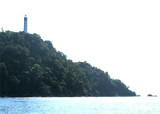
Stone tower with lantern and gallery, painted red with one very broad white horizontal band.
This light marks the extreme northwestern corner of
Indonesia. Breueh island was devastated by the tsunami of 26 December 2004, but this lighthouse
was far above the waves. Some ...
Good anchorage may be obtained during the Southwest Monsoon, in a depth of 12.8m, in Lhok Leuenbale, close SW of Ujung Puneus, on NE of Breueh island. Squalls from the hills are sometimes violent,the water is smooth, but a considerable sea sets in during the Northeast Monsoon.
Pulau Lheeblah (Kegel Island), the N island, lies about 2 miles 305° from the light on pulau Breueh. The sea will break on these islands even in moderate weather. There is a passage between Pulau Benggala (Northwest Island) and the inner islands but it is recommended to pass outside ...


 During the NE monsoon we can anchor in Balken Bay or Meulingge bay, in depths of from 14,6 to 16,5 m.
")
")