Approching, keep more than 2 NM off Punta Solano because of off lying rocks.
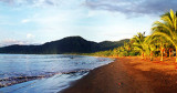
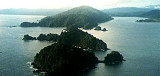
This is a Port of Entry and is a useful one if coming from Panama, being towards the north of Colombia's pacific coast.The bay is well protected but is open to the north.
There is an anchorage not far past the small military outpost and
near the little bar where the ferry pier is located. Anchor in about 60’
in uneven mud, but beware of rapid shoalling towards the shore.
The best dinghy landing is at the pier on the west side of the bay
where there is a bar with an outdoor shower and some provisions..
Tel: 4 682 7465
2016/01/8
Actualizar
Joëlle
Comparta sus comentarios o fotos en "Bahia Solano (Pacific Coast of Colombia)"
Sitios alrededor de Bahia Solano (Pacific Coast of Colombia)
National park with a park fee and anchoring fee. There is a small military force stationed here to watch the coast. The bay offer a very good protection.
Just North of bahia Solano is bahia Cupica. When approching be very carefull of punta Cupica. Rocks can be found as far as two miles of the land. Bay open to the S, si it is best visited during the dry season or when the winds are coming from the North.
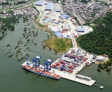
This port is located at about the midway point in Colombia's Pacific
coast. It has the reputaion of being one of the most violent cities in
the country. It's a port of entry.
Taboga island, also known as the "Island of Flowers", is a volcanic island in the Gulf of Panama, about 20 km from Panama city.At low tide, the northern end of the island is joined by a sand bar to
the small island of El Morro, and the southeastern end is 270 meters
from the neighboring ...
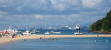
Located 6 miles S of La Playita. There are moorings for rent on both sides of the long touristic pontoon. At low tide and during the week the
beach is wide and nice, but at high tide it becomes small and dirty,
especially on Saturday and Sunday, when hundreds of local tourists ...


")
")
 Approching, keep more than 2 NM off Punta Solano because of off lying rocks.