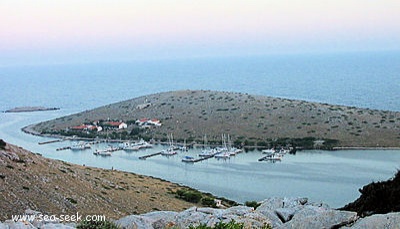
Otok Zirje (Sibenik)
15nm
114°
Elle fait environ 6,5NM de long (NW/SE) par 1,4 NM de large.
Le village principal, Zirje, est situé au milieu de l'île. Un petit port, luka Muna, sur la côte ...
11 Jul 11
Jojo
| Latitude | Longitude | |
| DMS | --- | --- |
| DM | --- | --- |
| DD | --- | --- |
 Kornati National Park
 Kornati National Park
 canal 17
 Limited, de 8h à 10 h
 Limited, de 8h à 12h, de 18h à 24h
 port Zaglav (Long island, 12 NM)


 Kornati National Park
 île longue et étroite au NW de Otok Lavsa. Il y a 2 îles et quelques roches sur la côte S. Otok Panitula Vela, la plus grande des 2 îles abrite la marina ACI Piskera.
En arrivant du Kornatski kanal, on passe entre O. Lavsa et O. Piskera.
En venant du large, on passe entre O. Lavsa et O. Panitula Mala.
On ne peut peut passer que par le SE pour accéder à la Marina, le chenal au N entre O. Piskera et O Panitula Vela étant peu profond et obstrué par des roches.

 Long and narrow island to the NW of Lavsa Otok. There are two islands and a few rocks on the coast of S. Panitula Otok Vela, the largest of two islands is home to the ACI Marina Piskera.
We can not go by the SE to access the Marina, the N channel between O. Piskera and O Panitula Vela is shallow and obstructed by rocks.
Anchor between 5 and less than 3 m.
Moor to The pontoons provide between 1.50 to 3 m of water.
The marina is open from late March to mid-October.
tel/fax: (099) 470 009
Mail: m.piskera@aci-club.hr
120 berths.
Good shelter from Bora, limited shelter from Sirocco.
Ebook | Srednji Kanal
|


