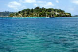
Ndeni
83nm
310°
7 Nov 07
Anonymous
| Latitude | Longitude | |
| DMS | --- | --- |
| DM | --- | --- |
| DD | --- | --- |

 French explorer Jean-François de La Pérouse was stranded on Vanikoro after both his vessels, La Boussole and the Astrolabe, struck the then unknown reefs of the island in 1788. It is reported that some of the men were killed by the local inhabitants, whilst the surviving sailors built a smaller vessel and left the island, but were never seen again. Those that remained on the island died before search parties arrived in 1826.
In 2005 the rests of the two ships "la Boussole" and " l'Astrolabe" were clearly identified.
 Lapérouse y fit naufrage en 1788. Peter Dillon y retrouva traces et témoignages du naufrage en 1826.
En 2005, les épaves de la Boussole et de l'Astrolabe, les deux navires de Lapérouse y ont été formellement identifiées, ainsi que les traces d'un campement à terre occupé durant plusieurs années.