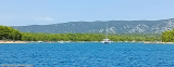
Large shallow bay protected by a chain of small islands N Otok Murter. The bay entrance is between a tag, the E Otocic Arta Mala and the mainland. The tips of each side of the entrance are overwhelmed by rocks. The bay itself is shallow, especially at the N and W. An advanced sand beneath 1.9 m of water stretching into the bay. We anchor by 5 to 10 m at the entrance of the bay.
2011/08/14
Update
Croatia
Grande baie peu profonde protégée par une chaîne de petites îles au N de Otok Murter.
L'entrée de la baie se fait entre une balise, à l'E de Otocic Arta Mala et le continent. Les pointes de chaque côté de l'entrée sont débordées de roches. La baie elle même est peu profonde, plus particulièrement au N et à l'W. Une avancée de sable sous 1,9 m d'eau s'étend au milieu de la baie.
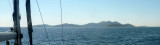
Otok Zirje
is the farthest and the largest island in the Sibenik archipelago. It is long of 6,5 NM (NW/SE) and 1,4 NM wide. The main village, Zirje, is located in the middle of the island. A small port, luka Muna, on the coast N of Zirje, home to the ferry that connects the ...
Vrgadski Kanal, 7 miles long, leads between Otok Murter and Otok Vrgada and is the principal channel used in the S approach to Pasmanski Kanal and Zadar. Vessels with a maximum draft of 6.4m may pass through Pasmanski Kanal. Vessels with drafts over 6.4m must either proceed through ...
Novigradsko More, a landlocked bay, lies at the S end of Novsko Zdrilo and provides good anchorage. Rijeka Zrmanja flows into the bay at the E side. This river is navigable by small craft as far as the village of Obrovca, 6 miles above the mouth. Luka Novigrad, a narrow inlet, ...
Kaprije is located in the central part of the Sibenik archipelago between the islands Zmajan and Kakan. The highlight of the island is Vela Glavica (132 m). The only village of the island is Kaprije, S. The port is busy. Automobiles are not allowed on the island.


 Large shallow bay protected by a chain of small islands N Otok Murter.
 Grande baie peu profonde protégée par une chaîne de petites îles au N de Otok Murter.

 Danger in the SW of the bay