Pulau Peunasoe (Nasi) (SE Breueh)
6.2nm
335°
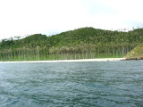
The coast line is rocky in places with sandy beaches chiefly on the W side.
11 Jan 12
Jojo
| Latitude | Longitude | |
| DMS | --- | --- |
| DM | --- | --- |
| DD | --- | --- |

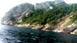
 Ujung Raja is a cape located in the area and state of Aceh. It is at 206 m above the sea.
Ujung Raya (Ujung Raja is a lofty promontory rising precipitously from
the sea and easily recognized from all directions; there are depths of
21.9m at a short distance from it.
A number of sunken dangers lie near the coast rendering it advisable to give it a berth of 5 or 6 miles, especially at night.
Most of the dangers are steep-to, as is the coast in most places, but they are generally seen by the surf breaking over them.
There are numerous prominent headlands and mountains by means of which the position of a vessel is easily verified.
An indifferent bottom almost everywhere, and the heavy ocean swell and poor shelter from W winds, render most places on this portion of the W coast as undesirable anchorages.
The coast between Ujung Raya to
Teluk Rigaih, about 57 miles SSE, is very irregular and has many
prominent headlands, with bays between, none of which afford secure
anchorage during the Southwest Monsoon.
 Ujung Raja est un cap situé dans la région et l'état d'Aceh. Il est à 206 m au-dessus de la mer.
Ebook | Andaman sea
|