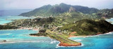
The Republic of Trinidad and Tobago is an archipelagic state in the southern Caribbean, lying just off the coast of northeastern Venezuela and south of Grenada in the Lesser Antilles.
Trinidad and Tobago was a Spanish colony from the times of Christopher Columbus. It was ceded to Britain in 1802 under the Treaty of Amiens.[9]
The country obtained independence in 1962, becoming a republic in 1976.
Unlike most of the English-speaking Caribbean, Trinidad and Tobago's
economy is primarily industrial,[10] with an emphasis on petroleum and petrochemicals.
2011/04/29
Update
dd
Trinité-et-Tobago
Trinité-et-Tobago est une république au sein du Commonwealth britannique et sa richesse découle de l'huile, de la pétrochimie et du gaz naturel, ainsi que le tourisme. Sa riche culture et de nombreux festivals refect la diversité ethnique de la population.
Climat équatorial dans la ceinture des alizés. La saison des pluies Juin à Novembre. Presque hors de la zone des ouragans.
2014/07/31
Update
loulousteven
Share your comments or photos on "Trinidad and Tobago"
Union est une des îles des Grenadines, archipel situé dans les petites Antilles entre l'île de Saint-Vincent au Nord et Grenade au Sud. Elle fait partie de l'état de Saint-Vincent et les Grenadines, dont c'est l'une des îles les plus méridionales.La ville et mouillage principal ...


 The Republic of Trinidad and Tobago is an archipelagic state in the southern Caribbean, lying just off the coast of northeastern Venezuela and south of Grenada in the Lesser Antilles.