Localisation
Tasmania sea
| Latitude | Longitude |
| DMS | --- | --- |
| DM | --- | --- |
| DD | --- | --- |
Description
Ebook | Tasmania sea- 24 sites
- 15 photos
- publication date: 6 Aug 2024
- .pdf file size: 11 Mb
|
Share your comments or photos on "Tasmania sea"
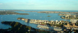
Sites around Tasmania sea
Flying distances - Direct line
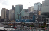
Darling Harbour
Enter your comments here.
Location
Provide details or delete
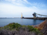
Entrance Navigation
Provide details or deleteGoat Island
Enter your comments here.
Location
Provide details or delete
Entrance Navigation
Provide details or deleteGarden island
Location
Private Island with a museum at the north end accessible by boat.