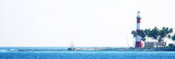
Sawai bay (Car Nicobar)

Sawai bay (Car Nicobar)

To precisely geolocate this site. Update if necessary.

Localisation

Sawai bay (Car Nicobar)
LatitudeLongitude
DMS------
DM------
DD------

Characteristics

Mooring
Sand
Beach
Sand

Description

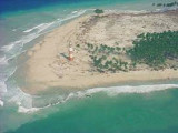
Sawai Bay indents the NW coast, between Keating Point and Hog Point, about 3.5 miles to SW.
Foul ground extends 1 mile N from Keating Point and 0.5 mile N from Hog Point. Sawai Village lies 0.5 mile SE of Hog Point.

The tidal currents off Sawai Bay set NE on the flood tide.

An observation spot lies on a small promontory that extends WNW from the coast about 1 mile S of Keating Point. Keating Point Light is shown from a round metal tower on the point; a racon and a radio beacon transmit from the tower.

A coral patch, with a least depth of 10.1m, was reported to lie about 0.7 mile NW of the observation spot. A 9.1m patch lies 0.8 mile WNW of the same spot.

Anchorage can be taken, in a depth of 21.9m, rock and coral over a thin layer of sand, about 0.8 mile N of Sawi Village.
Anchorage can also be taken in similar depths just over 1 mile W of the observation spot.

2011/11/28
Update
Jojo
Sawai bay (Car Nicobar)
2011-11-28
Update
Jojo
Ebook

Andaman sea

  • 178 sites
  • 164 photos
  • publication date: 7 Jul 2023
  • .pdf file size: 54 Mb
Share your comments or photos on "Sawai bay (Car Nicobar)"

Sites around Sawai bay (Car Nicobar)

Flying distances - Direct line

Chowra island (India)

49nm
159°
Chowra Island, which lies about 24 miles SSE of Batti Malv Island, is generally low but rises to a 104.5m high rocky pinnacle at its S end.
The island looks like a hat from the offing. Sanenya, the principal village, lies on the NE coast.
It has area of 8.2 sq km with a population ...
28 Nov 11
Jojo

Batti Malv island (India)

24nm
167°
Batti Malv Island (or Kuono), which lies about 17 miles SSE of Car Nicobar, appears wedge-shaped from the offing. It's an uninhabited island that covers an area of 2 square kilometers. This very small island rises to a densely wooded peak about 73m high. The NW end of the island is ...
28 Nov 11
Jojo

Nancowry island (India)

87nm
148°
Nancowry Island lies close S of and overlaps the S end of Camorta Island. Nancowry Harbor, a secure landlocked inlet, lies between them. The E entrance of Nancowry Harbor lies between the SE end of Camorta Island and the NE end of Nancowry Island. The approach to this entrance leads ...
29 Nov 11
Jojo

Bompoka island (India)

65nm
154°
Bompoka island lies about 1,8 NM east from southern end of nearby Teressa Island in the Nicobar group of islands. The hills on the island rise upto 193 m. The island has dense forest and some portions have grass growth. There is thick coconut palm growth on shores all round ...
29 Nov 11
Jojo