Petit port protégé par un quai à quatre bras entièrement bétonnés et d'un petit môle bétonné.
Dangers: cultures de moules à droite et à gauche en entrant dans le port.
Accès: la man?uvre d'entrée est difficile et dangereuse avec une mer agitéeet il est déconseillé dans ce cas d'y entrer pour les bateaux ayant un TE supérieur à 2 m.
Profondeur: de 0,50 à 5 m Tel: 040-676611 Mail: trieste@guardiacostiera.it 100 pl (<10 m)
2011/03/20
Update
Joëlle
2011-03-20
Update
Anonymous
E' un porticciolo protetto da un molo a quattro bracci interamente banchinato e da un piccolo moletto banchinato.
Pericoli: coltivazioni di mitili sia a dritta che a sinistra entrando nel porticciolo.
Accesso: la manovra di entrata è difficile e pericolosa con mare agitato ed è sconsigliabile, in tale circostanza, ai natanti con pescaggio superiore ai 2 m.
Fondali: da 0,50 a 5 m Tel: 040-676611 Mail: trieste@guardiacostiera.it 100 pb (<10 m)
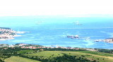
Koperski Zaliv (Baia di Capodistria) is entered between Rt Ronco and Rt Debeli, 5 miles NE.The NE and SW shores of the bay are hilly, but the shore at the head of the bay, through which the Fiume Risano flows, is low. Monte Sermino, surrounded by salt beds, rises isolated in the river ...
The Gulf of Piran or Piran Bay (Slovene: Piranski zaliv, Croatian: Piranski zaljev or Savudrijska vala, Italian: Baia di Pirano) is located in the northern part of the Adriatic Sea, and is a part of the Gulf of Trieste. It is between Rt Madona at N and Rt Saudrija. It was named ...
Le petit port de Grignano est protégé par un long quai en enrochement et un brise-lames muni de bites d'amarrage. Le rivage est complètement bétonné. A l'intérieur il y a deux pontons sur des échasses et deux quais flottants. Profondeur: 2,5 à 9 m. 350 pl (<20 m) Tel: ...


 canal 16
 Fontaine


 Petit port protégé par un quai à quatre bras entièrement bétonnés et d'un petit môle bétonné.
 E' un porticciolo protetto da un molo a quattro bracci interamente banchinato e da un piccolo moletto banchinato.