Santa Barbara

Santa Barbara

To precisely geolocate this site. Update if necessary.

Localisation

Santa Barbara
LatitudeLongitude
DMS------
DM------
DD------

Characteristics

Port
Water
Fuel
First aid
Grocery

Description

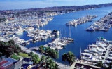
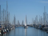
Small port protected by a breakwater.
2011/05/23
Update
NaraYasmin
Petit port protégé par une digue.
2011/05/23
Update
NaraYasmin
Santa Barbara
2011-05-23
Update
NaraYasmin
Ebook

California

  • 47 sites
  • 24 photos
  • publication date: 9 Jul 2023
  • .pdf file size: 24 Mb
Share your comments or photos on "Santa Barbara"

Sites around Santa Barbara

Flying distances - Direct line

Point Dume

50nm
119°
- Your comments are welcome - If you would like to add your own report on a marina, harbour, beach or anchorage please click on the "Edit" tab above, delete this text and type your comments. Digital photos are also very welcome using the "photo" link in the left menu. - Regards - The Webmaster
19 Aug 07

Marina del Rey

66nm
112°
Maximum Harbor Speed: 5 MPH .
Marina del Rey is a NO DISCHARGE HARBOR!
19 Aug 07