Samandag Limani

Samandag Limani

To precisely geolocate this site. Update if necessary.

Localisation

Characteristics

Port

Description

Ce port en construction, sans service offre un bon abri.
2010/10/10
Update
Joëlle
Samandag Limani
2010-10-10
Update
Joëlle
Ebook

Lycian Coasts - Likya Kiyilari (S Turkey)

  • 152 sites
  • 348 photos
  • publication date: 7 Jul 2023
  • .pdf file size: 75 Mb
Share your comments or photos on "Samandag Limani"

Sites around Samandag Limani

Flying distances - Direct line

Akinci Burnu

13nm
331°
Le cap Akinci
Ce cap se trouve à l'entrée S du golfe d'Iskenderun. Il porte un phare à son sommet qui fut construit en 1933. C'est le phare le plus proche du phare de la frontière syrienne. C'est un phare de pierre qui s'élève à 109 m au-dessus du niveau de la mer avec une ...
9 Oct 10
Joëlle

Iskenderun

30nm
24°
Small port protected by a breakwater.
18 Dec 11
NaraYasmin

Latakia

36nm
192°
Latakia or Latakiyah or Latakkia 
Al-Ladhiqiyah is the principal port city of Syria.
2 Jun 19
dd

Ayas Limani

38nm
351°
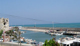
Ce petit port de pêche est situé au pied du village de Yumurtalik (ou Ayas). Deux petits îlots, dont un portant un fort, protège l'entrée du port.L'approche se fait par l'E en prenant garde aux ruines du vieux môle, situées au N de l'entrée et au banc de sable à l'extérieur ...
9 Oct 10
Joëlle

Karatas Limani

36nm
315°
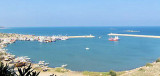
Karatas est un petit port situé à l'entrée N du golfe d'Iskenderun. Son entrée se trouve face à deux îlots qui sont précédés par quelques rochers, ce qui interdit toute approche par le S.On approche donc par l'E. La profondeur à l'intérieur est de 2 m.On accoste au quai E.Aucun service.
9 Oct 10
Joëlle

Baniyas

56nm
178°
Small harbor protected by a breakwater.
21 Jan 12
patrick_64