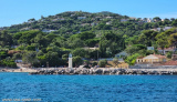
Located at the N end of the gulf of Grimaud opposite the port of St Tropez, this marina is divided into two basins. Well sheltered from all winds except Mistral which makes itself felt.
Port public (Public port)
T. 04 94 96 74 25
F. 04 94 43 82 03
389 B. (<15mx4,20m) incl. 30 visit.
Port Privé (Private port)
S of cental mole.
375 B. (5m to 26m)
fresh water
electricity
telephone
2012/03/25
Update
DD
Au S du môle central.
375 pl. (5m à 26m)
eau douce
électricité
téléphone
VHF 9
T. 04 94 96 06 27
F. 04 94 43 88 56
2007/11/26
Update
Situé sur la rive N du golfe de Grimaud, face au port de St-Tropez, le port de plaisance de Ste Maxime est divisé en deux bassins. Port abrité de tous les vents sauf du Mistral qui s'y fait sentir.
2012/03/25
Update
DD
Ste Maxime
Pont servant d'amer remarquable à l'ouest du port.
Prohibited areas, the limits of which are shown on the chart, lie SW of Pointe du Titan (Ile du Levant) and extend up to 2 miles from the coast. These areas, which are used by French naval vessels, are not in force between July 1 and August 31. Vessels are prohibited from approaching ...
Ile de Porquerolles lies centered 3 miles SE of Ponte de l’Esterel. The summit of the island, located 1 mile from its E end, is 142m high and surmounted by a signal station.
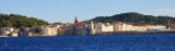
Situated on the lovely blue waters of the Bay of St. Tropez, the quay is lined with terrace cafes, perfect places to linger as the clientele admire the yachts docked there. Situated on the S side of the gulf of St-Tropez the harbour is made up of 2 basins (10 hectars) which get ...
La pointe des Sardinaux, à l'entrée du golfe de St Tropez, est une avancée basse, rocheuse où la mer peut briser dangereusement. Deux tourelles S et E balisent les roches affleurantes de la Sèche à l'Huile et des Sardinaux qui débordent de 900m la pointe N à l'entrée du ...


 public


 Located at the N end of the gulf of Grimaud opposite the port of St Tropez, this marina is divided into two basins.
 Au S du môle central.