To precisely geolocate this site. Update if necessary.
Localisation
SE Pacific Ocean
Latitude
Longitude
DMS
---
---
DM
---
---
DD
---
---
Characteristics
Description
Pacific Ocean, largest and deepest of the world's five oceans, covering more than a third of the earth's surface and containing more than half of its free water. The part south of the equator is called the South Pacific. The name Pacific, which means peaceful, was given to it by the Spanish Nuñez de Balboa.
2009/01/13
Update
anonymous
L'océan Pacifique Sud est délimité à l'est par l'Amérique du Sud, au sud, par l'océan Antarctique. Au sud-est, il est arbitrairement séparé de l'océan Atlantique par le passage Drake, le long du 68e méridien ouest.
Le courant marin El Niño (littéralement courant de l'Enfant Jésus, ainsi nommé parce qu'il apparaît peu après Noël), désigne un courant côtier saisonnier au large de l'Equateur et du Pérou, et par extension le phénomène climatique particulier qui diffère du climat usuel et qui se caractérise par une élévation anormale de la température de l'océan dans la partie est de l'océan Pacifique sud.
2009/01/13
Update
anonymous
Share your comments or photos on "SE Pacific Ocean"
The Republic of Peru is a country in western South America. It is bordered on the north by Ecuador and Colombia, on the east by Brazil, on the southeast by Bolivia, on the south by Chile, and on the west by the Pacific Ocean. Sailing Keep a close eye for small fishing ...
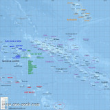
La Polynésie française comprend 118 îles réparties en un ensemble de 5 archipels français, situés dans le sud de l'Océan Pacifique, environ 6 000 km à l'est de l'Australie. Elle comprend: l'archipel de la Société ( îles du Vent et îles Sous-le-Vent), l'archipel ...
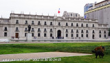
Chile, on the Pacific coast of S America, is defined by Peru at N, Bolivia at NE and Argentina at E. It extends over 4,300 km long, from Peru to Cape Horn, and 175 km wide on average (350 km to the level of Antofagasta and to the Tropic ...
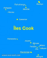
For those sailing to the Cook Islands, there are four ports of entry.The main entry is at Avarua harbour on the north coast of Rarotonga - fly your Q flag on arrival and a customs rep will meet come aboard.Other official ports of entry are Aitutaki, 140 miles to the north of Rarotonga, ...
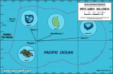
Les îles Pitcairn, la dernière colonie britannique dans l'océan Pacifique, est un ensemble de cinq îles d'une superficie totale de 47 km². Une seule d'entre elles est habitée par une cinquantaine d'habitants (neuf familles), ce qui en fait l'entité politique la moins ...


 Pacific Ocean, largest and deepest of the world's five oceans, covering more than a third of the earth's surface and containing more than half of its free water. The part south of the equator is called the South
 L'océan Pacifique Sud est délimité à l'est par l'Amérique du Sud, au sud, par l'océan Antarctique. Au sud-est, il est arbitrairement séparé de l'océan Atlantique par le passage Drake, le long du 68e méridien ouest.