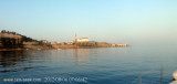
Cape Madonna (Rt Madona) is highlighted by the lighthouse located on a
bungalow / building: it is forbidden to anchor off the port of Piran (Piran), between Cape Madonna and fire the breakwater of the harbor to 300 meters from shore.
2011/08/28
Update
Jojo
Cap Madonna (Rt Madona) est mis en évidence par le phare placé sur une
guérite / bâtiment: il est interdit de mouiller devant le port de Piran
(Piran), entre le Cap Madonna et le feu du brise-lames du port jusqu'à
300 mètres du rivage.
2011/08/28
Update
Jojo
Capo Madonna (Rt Madona) è evidenziato dal faro posto su una
garitta/edificio: è vietato ancorarsi davanti al porto di Pirano
(Piran), tra Capo Madonna ed il fanale portuale in testa al frangiflutti
fino a 300 metri dalla riva.
Koperski Zaliv (Baia di Capodistria) is entered between Rt Ronco and Rt Debeli, 5 miles NE.The NE and SW shores of the bay are hilly, but the shore at the head of the bay, through which the Fiume Risano flows, is low. Monte Sermino, surrounded by salt beds, rises isolated in the river ...
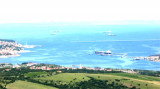
The Gulf of Piran or Piran Bay (Slovene: Piranski zaliv, Croatian: Piranski zaljev or Savudrijska vala, Italian: Baia di Pirano) is located in the northern part of the Adriatic Sea, and is a part of the Gulf of Trieste. It is between Rt Madona at N and Rt Saudrija. It was named ...
Warning: From Porec to the entrance to the Limski kanal there are a large number of dangerous shoals and rocks. On the N side of Funtana bay is the Janjci shoal, its northern edge is marked by a black post with two red bands and topped with two black spheres. At the southern ...
The port of Piran is located just south of Punta Madonna, and is protected by a breakwater with a SW direction and a pier breakwater oriented, NW, internally, from the root of the breakwater, there is a small dock protected by two Moletti. Inside the dock is a dock with two arms with ...
Limski Kana is entered between Rt Kriz, located 2.4 miles NW of Rovinj, and Rt Sjole, 1 mile NNW. The Lim bay and valley is a peculiar geographic feature found near Rovinj and Vrsar on the western coast of Istria, south of Porec, Croatia.The Lim valley is the 35 km long valley ...


 Cape Madonna (Rt Madona) is highlighted by the lighthouse located on a
bungalow / building: it is forbidden to anchor off the port of Piran (Piran), between Cape Madonna and fire the breakwater of the harbor to 300 meters from shore.
Cape Madonna (Rt Madona) is highlighted by the lighthouse located on a
bungalow / building: it is forbidden to anchor off the port of Piran (Piran), between Cape Madonna and fire the breakwater of the harbor to 300 meters from shore. Cap Madonna (Rt Madona) est mis en évidence par le phare placé sur une
guérite / bâtiment: il est interdit de mouiller devant le port de Piran
(Piran), entre le Cap Madonna et le feu du brise-lames du port jusqu'à
300 mètres du rivage.
Cap Madonna (Rt Madona) est mis en évidence par le phare placé sur une
guérite / bâtiment: il est interdit de mouiller devant le port de Piran
(Piran), entre le Cap Madonna et le feu du brise-lames du port jusqu'à
300 mètres du rivage. Capo Madonna (Rt Madona) è evidenziato dal faro posto su una
garitta/edificio: è vietato ancorarsi davanti al porto di Pirano
(Piran), tra Capo Madonna ed il fanale portuale in testa al frangiflutti
fino a 300 metri dalla riva.
Capo Madonna (Rt Madona) è evidenziato dal faro posto su una
garitta/edificio: è vietato ancorarsi davanti al porto di Pirano
(Piran), tra Capo Madonna ed il fanale portuale in testa al frangiflutti
fino a 300 metri dalla riva.