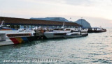
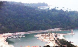
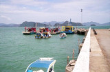
Royal langkawi YC is situated SE corner of Langkawi island close to the island'smain town. Immigration and Customs are conveniently situated just a few
minutes walk from RLYC marina.
200 berth (>60 m) Low tide depth of 3 m minimum in the basin Tel: +604 966 4078
Fax: +604 966 5078
E-mail: office@langkawiyachtclub.com
There is some swell from ferries.
Caution: Strong tidal cross-ways currents can get up to 4 knots during spring
tides. Incoming tide runs N to S and outgoing tide runs from S to N. If
possible, it's wise to enter or exit only during slack water, about one
hour after high or low water.
YC-Royal Langkawi est situé coin SE de l'île de Langkawi près de la ville island'smain. L'immigration et des douanes sont idéalement situés à quelques minutes à pied de RLYC marina.
200 couchettes (> 60 m) La profondeur à marée basse au minimum de 3 m dans le bassin Tél: +604 966 4078 Fax: +604 966 5078 E-mail: office@langkawiyachtclub.com
Il ya une certaine houle de ferries.
Attention: Forte marée croisée des chemins courants pouvez obtenir jusqu'à 4 nœuds lors des grandes marées. Marée tourne N à S et marée descendante va de S à N. Si possible, il est sage pour entrer ou sortir que durant l'étale, environ une heure après la marée haute ou basse
2011/12/14
Update
Jojo
Share your comments or photos on "Royal Langkawi Yacht Club (Langkawi)"
Pulau Tuba (5 km S of Langkawi) is the only inhabited island besides the main island of Langkawi itself. This Langkawi island gets its name from the tuba roots.
It is the only other island that offers accommodation and there are a few places to stay. At Pulau Tuba, you can experience ...
Located E coast of Malaysia.It's the most easterly anchorage for Langkawi. Being surrounded by a cluster of islands adds to the calm conditions in most winds, but being close to the open sea, sometimes there's a
bit of ground swell to contend with. The water is clean ...
Pulau Bumbon Besar and Pulau Bumbon Kechil are located less than 3 NM from Kuah, on the SE from Pulau Langkawi. Pulau Bumbon Besar has the shape of the letter M, with
two coves on the southern part. The island is uninhabited and rarely
visited. It is separated from another ...
A floating jetty, 144m in length, which can accommodate small vessels, is situated N of Batu Kuah Light. A T-shaped jetty, with a depth of 2m alongside, is located just S of the floating jetty. Tides—Currents.—It is HW, full and change, in Selat Dayang Bunting (Tyson Strait), ...
Pulau
Singa Besar is located about 17km from Kuah, nestled between the
smaller island of Pulau Beras Basah to the west and Pulau Dayang Bunting
to the east. The sedimentary rocks on this island are reputed to be
among the oldest in Malaysia going back 500 million years.This island ...
Bass Harbour is the main anchorage for
Kuah Town, it is formed between the S coast of Pulau Langkawi and the N coast of Pulau Dayang Bunting, is 7 miles in length with an average breadth of 1.5 miles and a general depth of 5.5 to 7.5m, mud bottom.. The harbour has two main areas ...


 channel 69


 free
free


")
 Royal langkawi YC is situated SE corner of Langkawi island close to the island'smain town.
")
")
")
 YC-Royal Langkawi est situé coin SE de l'île de Langkawi près de la ville island'smain.