Rade de Brusc lies between Ile des Embiez and the bank fronting the coast between Port de la Couduriere and Port du Brusc. This roadstead offers anchorage which is sheltered from winds from E through S to WSW. However, the holding ground is not good, especially in the N part where the bottom is formed by fine sand. A good anchorage berth lies in depths of 11 to 13m, with the N extremity of Ile du Grand Rouveau in line with Pointe Sainte-Pierre, N extremity of Ile des Embiez.
Toulon is a large military harbour on the Mediterranean coast, with a major French naval base.The prevailing winds are from the NW (Mistral) and W. These winds may reach a velocity of Force 11. Winds from the E and SE, which are less frequent, are generally accompanied by rain squalls, ...
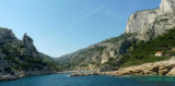
Les calanques de Marseille s'étendent sur plus de vingt kilomètres de côtes sur la mer Méditerranée entre le village des Goudes, quartier du sud-ouest de la ville de Marseille, et la commune de Cassis, dans les Bouches-du-Rhône. C'est un des sites les plus remarquables de France,
...
Ile de Porquerolles lies centered 3 miles SE of Ponte de l’Esterel. The summit of the island, located 1 mile from its E end, is 142m high and surmounted by a signal station.
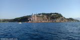
Golfe de Giens is entered between Pointe de Carqueiranne and Pointe Escampobariou, 4.7 miles SE. Pointe Escampobariou is the SW extremity of Presqu’ile de Giens, a peninsula, the W side of which is 118m high and surmounted by a tower. The E side of this gulf is bordered by ...
Zone au sud de la rade de Toulon avec de belles anses ouvertes sur le large. En cas de Mistral, on peut mouiller à l'Est du Cap Sicié près des 2 frères.


 Rade de Brusc lies between Ile des Embiez and the bank fronting the coast between Port de la Couduriere and Port du Brusc. This roadstead offers anchorage which is sheltered from winds from E through S to WSW. However, the holding ground is not good, especially in the N part where the bottom is formed by fine sand. A good anchorage berth lies in depths of 11 to 13m, with the N extremity of Ile du Grand Rouveau in line with Pointe Sainte-Pierre, N extremity of Ile des Embiez.