- Your comments are welcome - If you would like to add your own report on a marina, harbour, beach or anchorage please click on the "Edit" tab above, delete this text and type your comments. Digital photos are also very welcome using the "photo" link in the left menu. - Regards - The Webmaster
- Your comments are welcome - If you would like to add your own report on a marina, harbour, beach or anchorage please click on the "Edit" tab above, delete this text and type your comments. Digital photos are also very welcome using the "photo" link in the left menu. - Regards - The Webmaster
- Your comments are welcome - If you would like to add your own report on a marina, harbour, beach or anchorage please click on the "Edit" tab above, delete this text and type your comments. Digital photos are also very welcome using the "photo" link in the left menu. - Regards - The Webmaster
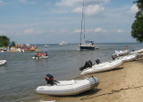
Have called at Fairlee Creek often over 14 years in 5' draft sailboat, s/v Lastdance. It is well marked but can be intimidating as you enter the very narrow cut between the spit of land to starboard and the beach to port, especially if a boat is outbound and/or there are people swimming; ...


 - Your comments are welcome - If you would like to add your own report on a marina, harbour, beach or anchorage please click on the "Edit" tab above, delete this text and type your comments. Digital photos are also very welcome using the "photo" link in the left menu. - Regards - The Webmaster