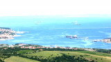
Koperski Zaliv (Baia di Capodistria) is entered between Rt Ronco and Rt Debeli, 5 miles NE.The NE and SW shores of the bay are hilly, but the shore at the head of the bay, through which the Fiume Risano flows, is low. Monte Sermino, surrounded by salt beds, rises isolated in the river ...
The Gulf of Piran or Piran Bay (Slovene: Piranski zaliv, Croatian: Piranski zaljev or Savudrijska vala, Italian: Baia di Pirano) is located in the northern part of the Adriatic Sea, and is a part of the Gulf of Trieste. It is between Rt Madona at N and Rt Saudrija. It was named ...
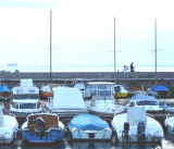
C'est le dernier petit port avant la frontière avec la Slovénie. Il est compposé d'un petit bassin bétonné protégé par un quai orienté S. Il existent quelques bites d'amarrage sur le côté externe du quai.Dangers: culture de moules à droite et à gauche en entrant dans le ...
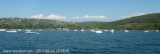
Baie de mouillage largement fréquentés en journée par les bateaux italiens. Au mileu de cette baie passe la frontière Italo-Slovène. L'entrée est difficile voire impossible de nuit car il ya une ferme marine coté italien et une coté slovène. Donc passer au milieu sur la frontière ...
Limski Kana is entered between Rt Kriz, located 2.4 miles NW of Rovinj, and Rt Sjole, 1 mile NNW. The Lim bay and valley is a peculiar geographic feature found near Rovinj and Vrsar on the western coast of Istria, south of Porec, Croatia.The Lim valley is the 35 km long valley ...


 At peak Sottile, you can see two tags painted with black and white bands used as the finish line.
 A pointe Sottile, vous pouvez voir deux balises peintes avec des bandes noires et blanches utilisées comme ligne d'arrivée.
 A Punta Sottile si notano due dromi dipinti a fasce bianche e nere, utilizzati da traguardo per una base misurata.
 Opera Figli del popolo a punta Sottile