Pulau Peunasoe (Nasi) (SE Breueh)
15nm
213°
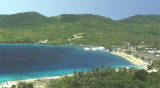
The coast line is rocky in places with sandy beaches chiefly on the W side.
11 Jan 12
Jojo
| Latitude | Longitude | |
| DMS | --- | --- |
| DM | --- | --- |
| DD | --- | --- |


")
Ebook | Andaman sea
|
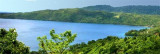
 Pulau Weh ((by the local population commonly referred to only as "Sabang", the name of the largest city), the largest of the islands off the N coast of Sumatra, is separated fromthe coast os Sumatra by Sempitan Malacca (Malacca passage), about 9 NM wide.
Kulam, the highest point of the island, is 657m high and is located 2 miles N of the SW point of the island.
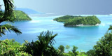
Except in a few places the coast is rocky, with the exception of Karang Berduri located off the S extremity of the island. Vessels can approach the island fairly close at any point. The E and W coasts are fairly straight, with deep water generally close to the N coast is indented by Lhok Perialakot and Teluk Sabang, and the S coast by Teluk Balohan.
Safe anchorage can only be obtained in the innermost portion of the large bays near the shore.
The W coast is bold, except for a sandy bay near its center. There is an explosive dumping ground centered 7 miles WNW of Ujung Bau.
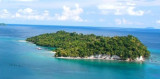
The island is known for its ecosystem; the Indonesian government has
declared 60 square kilometres (23 sq mi) of inland and sea around the
island as a wildlife protection area.
Coral reef areas around the island are known for their large variety of fish species.
There are four islets surrounding Weh Island: Klah, Rubiah, Seulako, and Rondo. Among those, Rubiah is well known for diving tourism, because of its coral reefs.