Pulau Rusa, 95m high, is a densely wooded island with a rugged coastline. In heavy sea, the water for a considerable distance W of the island becomes a light green color and gives the impression of there being a reef in the vicinity.
Pulau Nasi (Peunasoe or Aceh island), nearly joins the SE point of Pulau Breueh, being separated by Aroih Lam Puyang. The coast line is rocky in places with sandy beaches chiefly on the W side.
Ujung Pudeng lies about 6 miles SSE of Rusa. It is a low coastal point with a reef extending about 0.4 mile SE and 0.25 mile W. There is a shoal with depths of 3.2m located about 0.6 mile S of Poedeng. The sea usually breaks over this shoal.
Ujung Ritieng is the S entrance point of Teluk Kruengraba. The point is a precipitous headland with a rock above-water close off it and depths of 18.3m just beyond.
Teluk Karang Raba, lying 2,5 miles S of Ujung Raya, is about 4 miles wide. The mountains on either side make it appear as a valley when being a considerable distance off, and it has been mistaken for Aroih Cut.There is a cement-handling pier in the bay. The pier is 125m long with ...
Pulau Bunta (Pulau Boenta) lies between Aroih Raya and Aroih Cut (Aroih Tjoet).
Pulo Bunta is the least interesting of the bigger islands in Pulo Aceh. It
has a light house and a few beaches, but difficult to swim due to the
barrier reefs and strong currents. There are no people ...
Ujung Sidagung is a steep-to and rocky point close N of Ujung Seudheuen; the latter point is the termination of a high and very noticeable promontory, joined to the mainland by an isthmus covered with coconut palms. From Ujung Seudheuen to Raja Bay, about 14 miles SSE, the coast ...


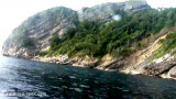
 Pulau Rusa, 95m high, is a densely wooded island with a rugged coastline.