Pulau Nasi (Peunasoe or Aceh island), nearly joins the SE point of Pulau Breueh, being separated by Aroih Lam Puyang. The coast line is rocky in places with sandy beaches chiefly on the W side.
Lhok Prialaut is the bay lying between Ug Bau and Ug Seukundo. 6,5 NM appart, between wich points the bay extends S for about 4 NM, with Teluk Sabang on its E shore. Lhok Prialaut is about 2 miles in length and breadth, with good anchorage near its head, in 16.5 to 21.9m. Tides—Currents.—The ...
Ujung Baka (Pedro point or Pedropunt), is the N point of Sumatera. The appearance of the coast has changes at Ujung Baka. W of it the coast is flat, but eastward it is hilly.
Karang Berduri, a rock small and awash, lies about 0.3 mile S of the S extremity of the island. A rock with a depth of 5.5m lies about 0.2 mile SE of the same point. There are usually strong tide rips or overfalls near these rocks and frequently they have been observed as breakers.
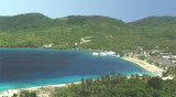
Teluk Balohan, on the SE side of Pulau We, is nearly 2 miles in length, and 1.5 miles in breadth across the entrance, with depths of from 54.9 to 128m in the outer part. A reef fringesthe E and W shores of the bay for a distance of 91m. A narrow coral bank fringes the shores of ...
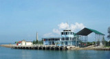
Ulee Lheue was a coastal port town near Banda Aceh, North Sumatra Indonesia. The name was made of two words. Ulèë means "head" and lheuë means” little peninsula”. Ulee Lheue is a coastal town on the tip of Sumatra Island. was a coastal port town near Banda Aceh, North Sumatra ...


 Pulau Buro, a rocky cone-shaped island, lies in Sempitan Malaka (Malacca Passage), about 4 miles WNW of Ujung Baka (Pedropunt).