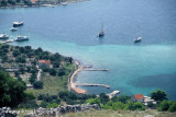
It is the passage located in the NW of the island Kornat, between it and the island Katina. The minimum depth in the passage is 1.9 m. The smallest part of this passage is indicated by four stone tags. On N enter, a cliff 250 meters to the west of the island Veli Buc, the bench of rock in the SE is indicated. Exposed to the Bora (strong blowing from different directions), the Jugo develops waves. Warning: sea current flows toward E with the speed of up to 2.5 knots.
2011/07/19
Update
Jojo
Prolaz Vela Proversa Kornati
2011-07-19
Update
Jojo
C'est le passage situé au NW de l'île Kornat, entre celle-ci et l'île Katina.
La profondeur minimale dans le passage est de 1,9 m. La plus petite partie de ce passage est indiquée par 4 pierres. Sur l'entrée N, une falaise à 250 m à l'W de l'îlot Veli Buc, le banc de roches au SE est indiqué.
Exposé à la Bora (qui souffle fort de différentes directions); le Jugo développe des ondes. Attention au courant qui se dirige vers l'E à une vitesse supérieure à 2,5 nœuds.
Kanal Nove Povljane, entered between Otok Vir and the SE end of Otok Pag, leads 5 miles SE into Ninski Zaliv. Shoals at the inner end of this channel restrict the fairway to a width of about 250m, with a controlling depth of 8m. Vessels with a draft of over 6m are advised not to ...
Vrgadski Kanal, 7 miles long, leads between Otok Murter and Otok Vrgada and is the principal channel used in the S approach to Pasmanski Kanal and Zadar. Vessels with a maximum draft of 6.4m may pass through Pasmanski Kanal. Vessels with drafts over 6.4m must either proceed through ...
Otok Zirje
is the farthest and the largest island in the Sibenik archipelago. It is long of 6,5 NM (NW/SE) and 1,4 NM wide. The main village, Zirje, is located in the middle of the island. A small port, luka Muna, on the coast N of Zirje, home to the ferry that connects the ...
Ninsko-Ljubacki Kanal, a tortuous channel, connects the SE end of Kanal Nove Povljane with Ljubacka Vrata. This channel leads through the deep inlets which indent the SE coast of Otok Pag, on the NW side, and the mainland, on the SE side. It is entered between Rt Prutna,which is ...
Novigradsko More, a landlocked bay, lies at the S end of Novsko Zdrilo and provides good anchorage. Rijeka Zrmanja flows into the bay at the E side. This river is navigable by small craft as far as the village of Obrovca, 6 miles above the mouth. Luka Novigrad, a narrow inlet, ...
Located at NW of Kornat. There are few houses and jetties. A center of Kornati Islands National Park will open in summer. Anchor by 10 m at the entrance. Beware the funds back to within 2 m further. This anchorage is permitted for the night, but the Bora blows here from several directions


 It is the passage located in the NW of the island Kornat, between it and the island Katina.
 C'est le passage situé au NW de l'île Kornat, entre celle-ci et l'île Katina.