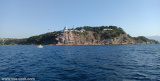
Port les Salettes, a small harbor, lies on the N shore of the gulf of Giens, 2.7 miles E of Pointe de Carqueirane.
It is formed by two jetties and is used by yachts and small craft. Hospital San Salvador, a large and prominent building, stands 1.5 miles E of the harbor.
Attention: the depth is limited to 1,6 m in the pass and 0,5 to 1,65 m in the port. Good shelter from the Mistral.
2015/08/9
Update
Atb
Au milieu de la côte N du golfe de Giens, le petit port des Salettes est bien abrité du Mistral, moyennement protégé du vent d'E, mais la profondeur est limitée de 0,5 à 2.5m dans le port suivant les pannes.
410 pl. dont 50 visit. (<10m) sur réservation
T. 04 94 58 56 25
Fax: 04 94 58 59 76
Commerces sur le port.
Vente de poissons frais par les pêcheurs locaux.
2015/08/9
Update
Atb
2015:07:18 19:12:26
2015-08-09
Update
Atb
Share your comments or photos on "Port Les Salettes-Carqueiranne"
Toulon is a large military harbour on the Mediterranean coast, with a major French naval base.The prevailing winds are from the NW (Mistral) and W. These winds may reach a velocity of Force 11. Winds from the E and SE, which are less frequent, are generally accompanied by rain squalls, ...
Ile de Porquerolles lies centered 3 miles SE of Ponte de l’Esterel. The summit of the island, located 1 mile from its E end, is 142m high and surmounted by a signal station.
Golfe de Giens is entered between Pointe de Carqueiranne and Pointe Escampobariou, 4.7 miles SE. Pointe Escampobariou is the SW extremity of Presqu’ile de Giens, a peninsula, the W side of which is 118m high and surmounted by a tower. The E side of this gulf is bordered by ...
Prohibited areas, the limits of which are shown on the chart, lie SW of Pointe du Titan (Ile du Levant) and extend up to 2 miles from the coast. These areas, which are used by French naval vessels, are not in force between July 1 and August 31. Vessels are prohibited from approaching ...
Zone au sud de la rade de Toulon avec de belles anses ouvertes sur le large. En cas de Mistral, on peut mouiller à l'Est du Cap Sicié près des 2 frères.


 canal 9


 Port les Salettes, a small harbor, lies on the N shore of the gulf of Giens, 2.7 miles E of Pointe de Carqueirane.