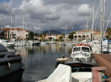
Port Grimaud is constitued of 3 ports: Port-Grimaud, Marina de Port-Grimaud and Port-Grimaud II.
Port-Grimaud
T. 04 94 56 29 88
F. 04 94 56 50 31
VHF 9
capitainerie@port-grimaud.fr
1100 pl. dont 283 visit (<30m, T.E max 3m)
e-mail: capitainerie@port-grimaud.fr
Marina de Port Grimaud
T. 04 94 56 02 45
F. 04 94 56 56 72
VHF 12
500 pl. dont 60 visit. (<20m)
e-mail: s.n.p.g@wanadoo.fr
Port-Grimaud II Sud
T. 04 94 56 73 65
F. 04 94 56 73 63
814 pl. dont 15 visit. (<18m)
e-mail: aslpg2@wanadoo.fr
2010/03/19
Update
cdg2
2010-03-19
Update
Anonymous
Port-Grimaud est une cité lacustre édifiée en bordure des canaux et des lacs creusés dans des terrains marécageux de la Giscle où se trouvait, dit-on Athénapolis, une cité lacustre grecque. Cette cité a été conçue par l'architecte François Spoerry qui, dès 1966, voulut créer une ville où des canaux remplaceraient les rues, et dont chaque habitant possèderait un bateau amarré devant sa porte. Port-Grimaud est constitué de trois ports: Port Grimaud, Marina de Port-Grimaud et Port-Grimaud II.
Prohibited areas, the limits of which are shown on the chart, lie SW of Pointe du Titan (Ile du Levant) and extend up to 2 miles from the coast. These areas, which are used by French naval vessels, are not in force between July 1 and August 31. Vessels are prohibited from approaching ...
Ile de Porquerolles lies centered 3 miles SE of Ponte de l’Esterel. The summit of the island, located 1 mile from its E end, is 142m high and surmounted by a signal station.
Port Cogolin is situated into the river "La Giscle", in the S end of the golf of St-Tropez between Grimaud and Cogolin ports. 150 B. visit received according to availability (<15m);
Marina is located at the far end of the golf of St-Tropez S of the river La Giscle. He comprise 4 basins. Public port or visiting port opposit entrance passage. The 3 basins La Galiote, La Cascadelle, La Brigantine are reserved for rented berths. Marina sheltered from all winds. ...
Toulon is a large military harbour on the Mediterranean coast, with a major French naval base.The prevailing winds are from the NW (Mistral) and W. These winds may reach a velocity of Force 11. Winds from the E and SE, which are less frequent, are generally accompanied by rain squalls, ...


 Port Grimaud is constitued of 3 ports: Port-Grimaud, Marina de Port-Grimaud and Port-Grimaud II.
 Port-Grimaud est une cité lacustre édifiée en bordure des canaux et des lacs creusés dans des terrains marécageux de la Giscle où se trouvait, dit-on Athénapolis, une cité lacustre grecque. Cette cité a été conçue par l'architecte François Spoerry qui, dès 1966, voulut créer une ville où des canaux remplaceraient les rues, et dont chaque habitant possèderait un bateau amarré devant sa porte.