Port NW French Guiana, on the east bank of the Maroni River opposite Albina, Suriname.
It was formerly headquarters of the country’s penal colonies and the
site of the largest prison, closed in 1944. Apart from its port
facilities, local economic activities include sawmilling, ...
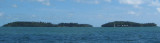
Îles du Salut, 3 in number, are located about 7 NM NE of Pointe Charlote.Ile du Diable, the northernmost, is 40m high. Ile Royale, 66m high, is the largest and westernmost, while Ile Saint-Joseph, only 30m high, is the southernmost.
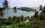
Île du Diable part of Salut islands is better known as Devil's Island. The total area is 0.62 km2 (62 hectares) The islands were used as a penal colony from 1852 onwards, earning them a reputation for harshness and brutality. This system was gradually phased out and has been completely ...
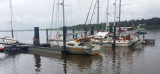
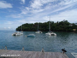
Anchorage can be taken in the bight formed by the S side of Ile Royale in depths of about 9m soft mud, good shelter from the swell, and good holding .ground.
Caution: Alouette Bank, covered with 4.8m of water, lies about 1.7 miles NNW of Ile Royale. Depths of 3.5 to 5.5m lie ...


 Pointe des Hattes marks the N limit of the French Guiana and the separation with Suriname country.