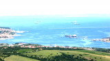
The Gulf of Piran or Piran Bay (Slovene: Piranski zaliv, Croatian: Piranski zaljev or Savudrijska vala, Italian: Baia di Pirano) is located in the northern part of the Adriatic Sea, and is a part of the Gulf of Trieste. It is between Rt Madona at N and Rt Saudrija.
It was named after the town of Piran, and its shores are shared by Croatia and Slovenia. It is delimited by a line connecting Cape Savudrija (Savudrijski rt) in the south to the Cape Madona (Rt Madona) in the north and measures around 19 square kilometres (7.3 sq mi). Since the 1990s, the name Bay of Savudrija (Savudrijska vala) has also been used in Croatia.
It has two coves, one of which houses the port Fazan Portoroz, and that of Secolvje.
2011/08/28
Update
Jojo
La baie de Piran, aussi appelée golfe de Piran, est une petite baie de la partie sud du golfe de Trieste, lui-même situé à l'extrémité septentrionale de la mer Adriatique, en Méditerranée. Elle est comprise entre Rt Madona au N et Rt Savudrija.
Si elle doit son nom à la commune de Piran, située en Slovénie, elle est également bordée par la Croatie et est à ce titre parcourue par une frontière maritime internationale, la frontière entre la Croatie et la Slovénie.
Elle comprend deux anses, celle de Fazan qui abrite le port de Portoroz, et celle de Secolvje.
Koperski Zaliv (Baia di Capodistria) is entered between Rt Ronco and Rt Debeli, 5 miles NE.The NE and SW shores of the bay are hilly, but the shore at the head of the bay, through which the Fiume Risano flows, is low. Monte Sermino, surrounded by salt beds, rises isolated in the river ...
Warning: From Porec to the entrance to the Limski kanal there are a large number of dangerous shoals and rocks. On the N side of Funtana bay is the Janjci shoal, its northern edge is marked by a black post with two red bands and topped with two black spheres. At the southern ...
Limski Kana is entered between Rt Kriz, located 2.4 miles NW of Rovinj, and Rt Sjole, 1 mile NNW. The Lim bay and valley is a peculiar geographic feature found near Rovinj and Vrsar on the western coast of Istria, south of Porec, Croatia.The Lim valley is the 35 km long valley ...
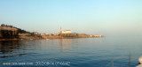
The port of Piran is located just south of Punta Madonna, and is protected by a breakwater with a SW direction and a pier breakwater oriented, NW, internally, from the root of the breakwater, there is a small dock protected by two Moletti. Inside the dock is a dock with two arms with ...


 The Gulf of Piran or Piran Bay (Slovene: Piranski zaliv, Croatian: Piranski zaljev or Savudrijska vala, Italian: Baia di Pirano) is located in the northern part of the Adriatic Sea, and is a part of the Gulf of Trieste. It is between Rt Madona at N and Rt Saudrija.
 La baie de Piran, aussi appelée golfe de Piran, est une petite baie de la partie sud du golfe de Trieste, lui-même situé à l'extrémité septentrionale de la mer Adriatique, en Méditerranée. Elle est comprise entre Rt Madona au N et Rt Savudrija.