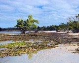
Pavilion Key, one of the Ten Thousand Islands, USA archipel, is located 30 miles N of Northwest Cape, in Mexico Gulf and. It's a part of National Everglades Park. It is the first prominent land seen after leaving Seminole Point.
Anchorage is available for drafts of 4 to 5 feet off the E point of the S end of Pavilion Key. The anchorage is exposed to SW winds. The approach to the anchorage passes close W of Dog Key, 0.3 mile SE of Pavilion Key.
2012/04/7
Update
India
Pavilion Key une des Dix milles îles, archipel des Etats Unis d'Amérique, elle est située à 30 M au N de Northwest Cape, dans le golfe du Mexique et relève du Parc National des Everglades. C'est la première terre que l'on aperçoit après avoir quitté Seminole point.
Les bateaux de 1,2 à 1,5 m de TE peuvent mouiller à l'E de l'extrémité S de Pavilion Key. Le mouillage, par 2 m de fond, est exposé aux vents du SW. Il faut passer entre Pavilion Key et Dog Key pour accéder au mouillage.
2012/04/7
Update
India
Share your comments or photos on "Pavilion Key (Florida)"
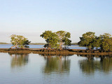
Lumber Key is one of the Ten Thousand Islands, USA archipelago in Mexico Gulf.Mooring in 4,6, feet, at Western of Lumber Key. Open to western, northwestern and southwestern winds.
New Turkey Key is one of the Ten Thousand Islands, USA archipelago located in Mexico Gulf, in SW Florida. It's a part of National Everglades Park.Mooring In NW Turkey Key, in 8 feet depth. Open to Northern and Southern winds.
Marco Island, Caxambas park. Marco Island est la plus grande des Dix Milles Îles de la Floride. Elle est située sur le golfe du Mexique au SW de la Floride, au S de Big Marco River, à 1 M environ de l'entrée de la passe Capri. Elle est reliée au continent par un pont.
Seminole point is located 24 miles N from Northwest Cape. It is fairly prominent when standing up the coast at a distance of 2 to 3 miles off. The point is the SW end of Plover Key, and is the most W land seen until Pavilion Key is picked up to the NW.
Kingston Key is one of the Ten Thousand, USA archipelago, located in Mexico Gulf, in Everglades National Park.Mooring at the Eastern shores of Kingston Key with 6 feet depth. Open to southwestern winds.


")
 Pavilion Key, one of the Ten Thousand Islands, USA archipel, is located 30 miles N of Northwest Cape, in Mexico Gulf and. It's a part of National Everglades Park. It is the first prominent land seen after leaving Seminole Point.
 Pavilion Key une des Dix milles îles, archipel des Etats Unis d'Amérique, elle est située à 30 M au N de Northwest Cape, dans le golfe du Mexique et relève du Parc National des Everglades. C'est la première terre que l'on aperçoit après avoir quitté Seminole point.