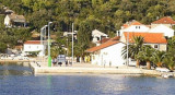
Small island at E of Dugi O. and Otok Iz. It is situated in the Zadar archipelago. Its area is 3,6km².
It has many coves shelteredof the Bora on the W coast. There are 3 villages, but the greatest is Rava, in the center of the island.
2011/09/11
Update
Jojo
Petite île à l'E de Dugi Otok et Otok Iz, elle fait partie de l'archipel de Zadar. Elle a une surface de 3,6 km². Elle comprend plusieurs anses abritées de la Bora sur la côte W. Il y a 3 villages mais le plus grand est Rava, au centre de l'île.
Kanal Nove Povljane, entered between Otok Vir and the SE end of Otok Pag, leads 5 miles SE into Ninski Zaliv. Shoals at the inner end of this channel restrict the fairway to a width of about 250m, with a controlling depth of 8m. Vessels with a draft of over 6m are advised not to ...
Otok Olib is located E of O. Silba. It belongs to Zadar archipelago.The island has been inhabited since Roman times. The residents bought their island in 1900. The only village on the island was established around the port. To the east of the island you will find some small hidden ...
Ninsko-Ljubacki Kanal, a tortuous channel, connects the SE end of Kanal Nove Povljane with Ljubacka Vrata. This channel leads through the deep inlets which indent the SE coast of Otok Pag, on the NW side, and the mainland, on the SE side. It is entered between Rt Prutna,which is ...
Olipski Kanal leads NNW between the E side of Otok Silba and the W side of Otok Olib and merges into the N end of Pohlipski Kanal. This channel is deep and has a minimum navigable width of 0.7 mile. It is often used by vessels proceeding to and from Zadar. Good anchorage is ...
Novigradsko More, a landlocked bay, lies at the S end of Novsko Zdrilo and provides good anchorage. Rijeka Zrmanja flows into the bay at the E side. This river is navigable by small craft as far as the village of Obrovca, 6 miles above the mouth. Luka Novigrad, a narrow inlet, ...
Located on the W coast, just after the light of Rt Garmina. There are some houses around the cove and the island village is near.Coming from the N, beware to the low rocky islet S of Rava in access N Ravski Kanal, about 1 NM to the NW of Rt Garmin. Coming from the SE, beware ...


 Small island at E of Dugi O. and Otok Iz. It is situated in the Zadar archipelago.
 Petite île à l'E de Dugi Otok et Otok Iz, elle fait partie de l'archipel de Zadar.