Localisation
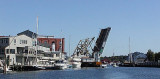
Mystic Harbor
| Latitude | Longitude |
| DMS | --- | --- |
| DM | --- | --- |
| DD | --- | --- |
Description

Small port.
2011/04/27
Update
Anonymous

Petit port.
2011/04/27
Update
Anonymous
Ebook | US - East coast- 190 sites
- 66 photos
- publication date: 4 Aug 2024
- .pdf file size: 142 Mb
|
Share your comments or photos on "Mystic Harbor"
Sites around Mystic Harbor
Flying distances - Direct line