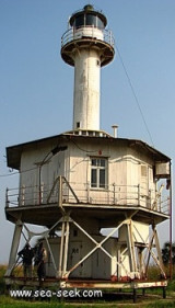
Kipundji69nm266°Kipundji ou KupundjiWhite flash every 5 seconds, visible for 15 nautical miles.9 Dec 15anonymous
Port de Banana63nm259°Le Port de Banana se trouve sur la rive nord de l'embouchure du Congo.15 Jan 09anonymous
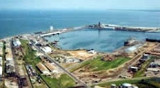
Pointe-Noire (Congo)115nm302°Pointe Noire is the seaport for the Congo, on the western coast of Africa. The port of Pointe-Noireis a vital communication axis in equatorial Africa, stretching from Pointe-Noire to Bangui and Ndjamena, through the railway line.Pointe_Noire14 Jan 09anonymous


 Port .
 Port .