Masan

Masan

To precisely geolocate this site. Update if necessary.

Localisation

Masan
LatitudeLongitude
DMS------
DM------
DD------

Characteristics

Water
Fuel
First aid
Shipyard
Grocery
Harbour

Description

Harbor.
2013/03/2
Update
OlivierLD
Port de commerce côtier.
2013/03/2
Update
OlivierLD
Masan
2013-03-02
Update
OlivierLD
Ebook

East Sea 

  • 22 sites
  • 22 photos
  • publication date: 11 Jul 2023
  • .pdf file size: 11 Mb
Share your comments or photos on "Masan"

Sites around Masan

Flying distances - Direct line

Jinhae Naval Base

8.7nm
127°
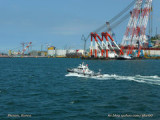
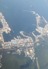
Naval Base.The Republic of Korea Navy strictly controls access to the Port and facilities. USN and ROKN surface ships and submarines use specific piers within the Port. There is no commercial usage within the Port. Vessels with drafts of up to 7.9m can be accommodated. 
26 Oct 17
dd

Pusan

24nm
102°
Large harbor protected by a breakwater.
2 Mar 13
emailaddress

Gwangan Bridge

27nm
95°
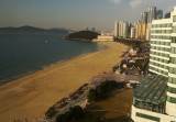
The Gwangan Bridge or Diamond Bridge is a suspension bridge whic connects Haeundae-gu to Suyeong-gu. The road surface is about 6,500 meters long, with the bridge as a whole spanning 7,420 meters. It is the second longest bridge in ...
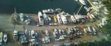
24 Oct 15
dd

Dongbaek

28nm
94°
Dongbaekseom Island in Busan used to be an island, but is now part of the mainland. 
27 Oct 17
dd

Haeundae beach

29nm
93°
Large sandy beach crowded during summer time.
26 Oct 17
dd