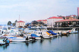
Izola / Isola is a town in the Republic of Slovenia, located near the Italian border on the Adriatic coast. The city is bilingual Slovene - Italian, Slovenian name of the city is Izola, the name is Italian Isola d'Istria. The marina is located in the western part of the fishing town. It is divided into two basins, right basin has 8 wharfs for ships of large capacity and left the pool has 4 platforms for small units. * 650 pl. (8 to 30 m) * T. + +386 5 662 54 00 * F. + +386 5 662 54 06 * Mr. info@marinaizola.com
2012/08/14
Update
Atb
2012:08:05 19:03:45
2012-08-14
Update
Atb
2011/03/21
Update
Joëlle
Izola/ Isola est une ville de la République de Slovénie, située près de la frontière italienne sur la côte Adriatique. La ville est bilingue slovène - italien, le nom slovène de la ville est Izola, le nom italien est Isola d'Istria. La marina se trouve dans la partie occidentale de la ville de pêcheurs. Elle est divisée en deux bassins, à droite le bassin possède 8 quais pour navires de grande capacité et à gauche, le bassin possède 4 quais pour les petites unités.
*650 pl. (8 à 30 m)
*T. ++386 5 662 54 00
*F. ++386 5 662 54 06
*M. info@marinaizola.com
2011/03/21
Update
Joëlle
Share your comments or photos on "Marina d'Izola Isola"
Koperski Zaliv (Baia di Capodistria) is entered between Rt Ronco and Rt Debeli, 5 miles NE.The NE and SW shores of the bay are hilly, but the shore at the head of the bay, through which the Fiume Risano flows, is low. Monte Sermino, surrounded by salt beds, rises isolated in the river ...
The Gulf of Piran or Piran Bay (Slovene: Piranski zaliv, Croatian: Piranski zaljev or Savudrijska vala, Italian: Baia di Pirano) is located in the northern part of the Adriatic Sea, and is a part of the Gulf of Trieste. It is between Rt Madona at N and Rt Saudrija. It was named ...
Limski Kana is entered between Rt Kriz, located 2.4 miles NW of Rovinj, and Rt Sjole, 1 mile NNW. The Lim bay and valley is a peculiar geographic feature found near Rovinj and Vrsar on the western coast of Istria, south of Porec, Croatia.The Lim valley is the 35 km long valley ...
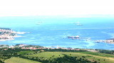
Located at the W cape Gallo (Rt Petelin). The old town Izola was built on what was once an island. There are some industrial activities, including tall chimneys, the S port, are remarkable. Vessels whose TE is less than 4 m may dock along the W side of the breakwater.


 canal 17


 50 T.
50 T.


 Izola / Isola is a town in the Republic of Slovenia, located near the Italian border on the Adriatic coast. The city is bilingual Slovene - Italian, Slovenian name of the city is Izola, the name is Italian Isola d'Istria.
 Izola/ Isola est une ville de la République de Slovénie, située près de la frontière italienne sur la côte Adriatique. La ville est bilingue slovène - italien, le nom slovène de la ville est Izola, le nom italien est Isola d'Istria.