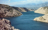
Vinjerac is a small village with a harbour on the S coast of the Velebitski kanal.
Warning: rock located approximately 0.5 NM NW port, indicated by a tag cardinal N without fire. Halfway the rock and fire of the port, there is a shoal covered about 6.2 m. Coast to E Vinjerac is shallow at least 0.1 M. We moored on the outer breakwater of 1.5 m and 6 m. Good protection except from Bora and NW.
2011/03/28
Update
Joëlle
Vinjerac est un petit village avec un port sur la côte S du canal Velebitski.
Attention au rocher situé à environ 0,5 M au NW du port, signalé par une balise cardinale N sans feu. A mi-distance du rocher et du feu du port, il y a un haut-fond couvert d'environ 6,2 m. La côte à l'E de Vinjerac est peu profonde sur au moins 0,1 M.
On s'amarre sur le brise-lames externe entre 1,5 m et 6 m.
Novigradsko More, a landlocked bay, lies at the S end of Novsko Zdrilo and provides good anchorage. Rijeka Zrmanja flows into the bay at the E side. This river is navigable by small craft as far as the village of Obrovca, 6 miles above the mouth. Luka Novigrad, a narrow inlet, ...
Kanal Nove Povljane, entered between Otok Vir and the SE end of Otok Pag, leads 5 miles SE into Ninski Zaliv. Shoals at the inner end of this channel restrict the fairway to a width of about 250m, with a controlling depth of 8m. Vessels with a draft of over 6m are advised not to ...
Ninsko-Ljubacki Kanal, a tortuous channel, connects the SE end of Kanal Nove Povljane with Ljubacka Vrata. This channel leads through the deep inlets which indent the SE coast of Otok Pag, on the NW side, and the mainland, on the SE side. It is entered between Rt Prutna,which is ...
Vrgadski Kanal, 7 miles long, leads between Otok Murter and Otok Vrgada and is the principal channel used in the S approach to Pasmanski Kanal and Zadar. Vessels with a maximum draft of 6.4m may pass through Pasmanski Kanal. Vessels with drafts over 6.4m must either proceed through ...
Nosko Zdrilo (Maslenicki Kanal) is entered at the N end between Rt Baljenica, a conspicuous brown and yellowish point, and Rt Korotanja, 0.2 mile SW. These entrance points are fringed by shoals which are marked by buoys. The fairway of the entrance has a least depth of 7.9m. ...
Otok Zirje
is the farthest and the largest island in the Sibenik archipelago. It is long of 6,5 NM (NW/SE) and 1,4 NM wide. The main village, Zirje, is located in the middle of the island. A small port, luka Muna, on the coast N of Zirje, home to the ferry that connects the ...


 robinet au vi

 marché
 Vinjerac is a small village with a harbour on the S coast of the Velebitski kanal.
 Vinjerac est un petit village avec un port sur la côte S du canal Velebitski.