Caché derriere la jeté de la marina et bloti entre l'ancien port des pêcheurs, possibilité de mouiller avec bout a terre, quelques corps morts et un quai avec quelques places. La police de la marina (en cheville avec la marina) explique c'est interdit, nous avons trouvé de la ...
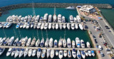
Limassol (Greek: Lemesos; Turkish: Limasol, alt. Leymosun) is the second-largest city of Cyprus. The city is located on Akrotiri Bay, on the island's southern coast. There are 237 berths accommodating boats up to 30m LOA and 4m draught.
When arriving berth at the arrivals ...
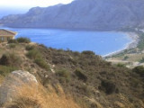
Wind Due to the topography of the island, the port is well protected from northerly winds.Southeast winds are the most dangerous for the area. These winds can cause the highest swell that can last for 2 days even after winds have subsided.


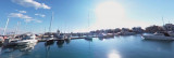


 Port protected by a breakwater.
 Port protégé par une digue.