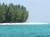
Koh Tanga and Koh Chuku, halfway between Butang and
Tarutao offer great snorkelling, diving and fishing. The best anchorage is found on the east or west coasts
between the north and south Tangas, depending on wind
direction and ground swell. Alternative daytime anchorage
can ...
Pulau Tuba (5 km S of Langkawi) is the only inhabited island besides the main island of Langkawi itself. This Langkawi island gets its name from the tuba roots.
It is the only other island that offers accommodation and there are a few places to stay. At Pulau Tuba, you can experience ...
Located E coast of Malaysia.It's the most easterly anchorage for Langkawi. Being surrounded by a cluster of islands adds to the calm conditions in most winds, but being close to the open sea, sometimes there's a
bit of ground swell to contend with. The water is clean ...
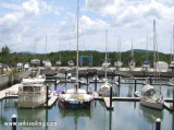
Royal Phuket Marina has opened and is the first international standard marina in Thailand. Full facilities / mooring / hardstanding / repairs / fuel / restaurants etc. Also yacht charter on Sunseeker Predators 60 ft yachts. www.CharterYachtsPhuket.com The photo , the coordonates ...


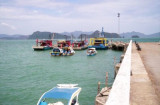
 Small port.
 Petit port côtier.