Ciovo is an island in the center of the Dalmatian archipelago. This is an area of 28.8 acres (15.3 km length, width of 3.5 km). It culminates at 218 m (Mount Rudin). O. Ciovo forms the SW side of the entrance and inner part of Kastelanski Zaliv. At East side, Ciovo is 2km from ...
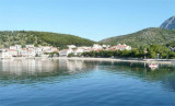
Uvala Drevnik is a small bay with a small fishing port on one side and a pier for the ferry that links with O. Hvar, on the other side. You can anchor in the bay, by 7 m. Sheltered N and E.
Novigradsko More, a landlocked bay, lies at the S end of Novsko Zdrilo and provides good anchorage. Rijeka Zrmanja flows into the bay at the E side. This river is navigable by small craft as far as the village of Obrovca, 6 miles above the mouth. Luka Novigrad, a narrow inlet, ...
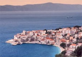
Igrane is a picturesque village on the Makarska Riviera. The village overlooks the sea, port, and the long beach of gravel and sand. Above the square is the steeple of the church of Our Lady of the Rosary which seems to watch over the village and its inhabitants. In the vicinity there ...
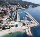
The marina is located in the center of the small seaside town of Tucepi. Approaching by the S, attention to the rocks at 0.2 NM offshore, at about 0.5 NM N of Rt Dracevac. The main landmark is the modern bell tower above the town. The party at the entrance to the marina ...