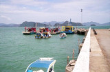
On the NE coast of Langkawi, the Hole in the Wall Fishfarm & Restaurant, is not just the only
floating restaurant in Langkawi it offers also the only watched yacht
parking lot on a river arm inside the Kilim Mangrove Forest.
Take your boat up along the southern, eastern and north eastern
coastline and turn into the Kilim river through the Hole in the Wall
passage. Continue for approx 1/2 mile to river
arm on right.
Anchor by 2/10 m, and proceed by dinghy to Floating Restaurant and
speak to Rahmad for directions to your mooring. Staff will assist with
mooring. Free water. Internet available.
Current can be strong at springs. Take care if swimming.
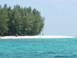
Pulau Tuba (5 km S of Langkawi) is the only inhabited island besides the main island of Langkawi itself. This Langkawi island gets its name from the tuba roots.
It is the only other island that offers accommodation and there are a few places to stay. At Pulau Tuba, you can experience ...
Located E coast of Malaysia.It's the most easterly anchorage for Langkawi. Being surrounded by a cluster of islands adds to the calm conditions in most winds, but being close to the open sea, sometimes there's a
bit of ground swell to contend with. The water is clean ...
Tanjung Rhu
has 2 choices of anchorage. The outer area just after entering the bay from the northern channel is fairly restricted for where you can anchor, as a lot of it has shoals in the southern part.
It can also get lumpy if winds freshen out of the West or NW. To enter ...
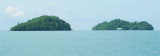
Pulau Bumbon Besar and Pulau Bumbon Kechil are located less than 3 NM from Kuah, on the SE from Pulau Langkawi. Pulau Bumbon Besar has the shape of the letter M, with
two coves on the southern part. The island is uninhabited and rarely
visited. It is separated from another ...
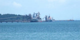
Langkawi port is situated at Teluk Ewa, on the N side of Pulau Langkawi. It is designed to handle petroleum products, coal, and general cargo. The major exports include cement and clinker.The port is entered through a channel marked with buoys and lighted buoys. The seaward ...


 jetty
jetty


")
")
 On the NE coast of Langkawi, the Hole in the Wall Fishfarm & Restaurant, is not just the only
floating restaurant in Langkawi it offers also the only watched yacht
parking lot on a river arm inside the Kilim Mangrove Forest.
On the NE coast of Langkawi, the Hole in the Wall Fishfarm & Restaurant, is not just the only
floating restaurant in Langkawi it offers also the only watched yacht
parking lot on a river arm inside the Kilim Mangrove Forest.")
")