


Hawaii island
131nm
122°
Major commercial ports are Hilo on the East side and Kawaihae on the West side of the island. Cruise ships often stop at Kailua-Kona.
14 Dec 15
Joëlle
| Latitude | Longitude | |
| DMS | --- | --- |
| DM | --- | --- |
| DD | --- | --- |

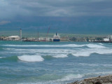
 Hawaii is one of the most isolated group of islands in the world. It's a long way to Hawaii from mainland USA with nothing but open sea between. Winter storms can bring about rough seas and cyclones are a threat in late summer.
Renting small hoby cats is more practical and can be done at most major resorts around the islands.
The climate is subtropical in the low coastal areas and temperate in the mountains. There is no rainy season but showers, sometimes downpours, occur in winter. The islands are under the influence of the NE trade winds and are only rarely affected by tropical cyclones.
The Department of Land and Natural Ressources (DLNR) has established rules that all boaters in Hawaiian islands must follow.
The first rule to remember is that you can anchor in any anchorage for 72 hours without checking in. The one exception is that you must check in immediatly whenever you enter a harbor with a harbormaster on site, such as Ala Wai, Ke'echi, Wai'anae, Hale'Iwa, He'ela Kea, Kaunakakai, Hilo, Honokôhau, Lahaina, Ma'alaea, Mânele, Kahului, or Port Allen.
After the first 72 hours is up, boaters are required to move to another anchorage or even to another part of the same anchorage.
The exceptions to this right to anchor in any anchorage for 72 hours are the areas that are part of Marine Conservation District or Natural Area. All or part of some bays have been placed in Conservation District because the heavy traffic and the delicate ecosystem on the bottom of the bay required intervention on the part of the State of Hawaii.
Boaters may not anchor in part or all of the following bays:
Hâ'ena bay: boats may not anchor inside the reef overnight
Hanauma bay: no boats allowed in this bay
Hulopo'e bay: no boats allowed in the bay
Kealakekua bay: boats may not anchor in Subzone A
La Perouse bay: boats may not anchor in the western half of the bay
Waikiki anchorage: no boats allowed within 4 mile of the beach.
When boaters visit small boat harbors in Hawaii, they must obtain a permit from the harbormaster and pay a daily fee, as is the case in harbors anywhere. The difference here is that the facilities are not the plush ones some boaters might be accustomed to elsewhere. Although some might complain about the facilities, the low daily rate charged to visiting boaters more than makes up for any shortage in facilities.


 Hawaii est un archipel de 137 îles. C'est le plus isolé du monde. C'est un des états des USA, mais le trajet est long pour aller à Hawaii depuis les USA! Hawaii est le seul état américain situé en dehors du continent Nord-américain, puisquil est situé en Océanie.
Les 8 îles principales sont Nihau, Kauai, Molokai, Lanai, Kahoolawe, Maui, l'île d'Hawai et Oahu où se trouve la capitale Honolulu.
L'archipel fait partie de la Polynésie et se situe dans l'océan pacifique central à environ 3 900 km au SW des côtes californiennes, au SE du Japon et au NE de l'Australie.
Les tempêtes hivernales peuvent engendrer une mer agitée tandis que les cyclones sont une menace à la fin de l'été.
Des marinas, entièrement équipées, se trouvent à Honolulu et KoOlina sur Oahu, Lithue sur Kauai, Honokohau (Kailua) sur la grande île et Lahaina sur Maui.
Les baies de Hanalai et Poipu sur Kauai sont aussi des points de mouillage populaires.
La location de petits hoby cats est très pratiquée et peut se faire dans la plupart des stations autour des îles.
Le climat des îles Hawaii est directement influencé par l’anticyclone du Pacifique Nord qui génère des alizés de Nord-Est pouvant atteindre 20 à 25 nœuds au cours de l’été, faiblissant au début de l’automne, quand l’anticyclone régresse vers le Sud. Il y a alors souvent de longues périodes de vents légers de Sud-Ouest à Nord associés au passage des fronts.
A cause de la nature montagneuse des îles, il y a sous le vent de l’archipel de nombreuses zones de calme ou avec des brises de mer opposées à la direction générale des alizés, permettant de parcourir facilement l’archipel dans les deux sens. Comme aux Açores ou aux Canaries et par effet Venturi, le vent accélère significativement (jusqu’à + 30%) levant une mer courte et parfois assez rude dans les passes entre les îles.
Ebook | Hawaii
|