Funafuti is an atoll that forms the capital of the island nation of Tuvalu. It has a population of 4,492 (2002 Census), making it the most populated atoll in the country.
It is a narrow sweep of land between 20 and 400 metres wide, encircling
a large lagoon 18 km long and 14 km wide, with a surface of 275 km², by
far the largest lagoon in Tuvalu. The land area of the 33 islets
aggregates to 2.4 km², less than one percent of the total area of the
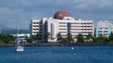
atoll. There is an airstrip, hotel (Vaiaku Langi Hotel),
and administrative buildings, as well as homes, constructed both in the
traditional manner, out of palm fronds, and more recently out of cement
blocks. The most prominent building on Funafuti atoll is the Church of Tuvalu. Other sites of interest are the remains of United States aircraft that crashed on Funafuti during World War II, when the airstrip was used by the U.S. forces to defend the Gilbert Islands and the Marshall Islands.