The French Creek Boat Basin is undergoing breakwater construction (2011~2012) The radar image has been altered if approching from the East. Inside the breawater, temporary buoys have been installed over the old and removed sections. Completion is expected by September 2012 and depths will be maintained at 3 metres below Low Water
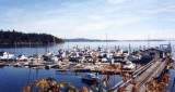
Mill Bay, British Columbia, is located on the east side of Vancouver Island, about 25 miles north of Victoria. The blue waters of the Saanich Inlet and the majestic mountain views, make the perfect setting for Mill Bay Marina. Close to all the amenities of the city, but quiet and ...


 The French Creek Boat Basin is undergoing breakwater construction (2011~2012) The radar image has been altered if approching from the East. Inside the breawater, temporary buoys have been installed over the old and removed sections. Completion is expected by September 2012 and depths will be maintained at 3 metres below Low Water