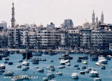
La navigation de
plaisance peut être pratiquée le long de la côte
méditerranéenne, le long du Nil et la Mer Rouge. Les lieux les plus appropriés à la
navigation de plaisance se trouvent sur la péninsule du Sinaï, à Charm
el-Cheikh ou Dahab, mais également Hurghada et El Gouna.
The "sailing club" is just in front of the fort placed in the old phare
is not more than a modern construction without boats. If you are a good
detectiv, you can discover the rest of Cleopatra. The modern bibloteque is in the place were was the old, in my opinion the modern building is awfull.


 La navigation de
plaisance peut être pratiquée le long de la côte
méditerranéenne, le long du Nil et la Mer Rouge. Les lieux les plus appropriés à la
navigation de plaisance se trouvent sur la péninsule du Sinaï, à Charm
el-Cheikh ou Dahab, mais également Hurghada et El Gouna.
La navigation de
plaisance peut être pratiquée le long de la côte
méditerranéenne, le long du Nil et la Mer Rouge. Les lieux les plus appropriés à la
navigation de plaisance se trouvent sur la péninsule du Sinaï, à Charm
el-Cheikh ou Dahab, mais également Hurghada et El Gouna.