Dhow Harbor (Abu Dhabi)

Dhow Harbor (Abu Dhabi)

To precisely geolocate this site. Update if necessary.

Localisation

Dhow Harbor (Abu Dhabi)
LatitudeLongitude
DMS------
DM------
DD------

Characteristics

VHF canal 9, 67
Water
Fuel
Mechanical repair
Shipyard
Grocery market
Restaurant
Harbour

Description

Dhow Harbor (Abu Dhabi)
2011-09-24
Update
Jojo
Ebook

Persian Gulf - Arabian Gulf

  • 61 sites
  • 71 photos
  • publication date: 7 Jul 2023
  • .pdf file size: 37 Mb
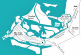
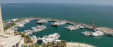
The Dhow Harbour in Abu Dhabi, is located in close proximity to Mina Zayed, has been developed as a Free Port for oil rigs supply vessels, buoys tug boats as well as traditional Arab dhows and launches for prompting active trade between Abu Dhabi and the Gulf countries, the Indian Sub-Continent, East Africa and most parts of the Middle East.
All the berths have independent fresh water connections. Three fuel stations owned and administered by ADNOC-Fod provided necessary fuel for 
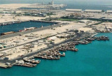
the users. The Free Port operates round-the-clock and is fully equipped with all the necessary equipment essential for normal handling of goods in the harbor. Handling equipment, when required, is supplied by the 
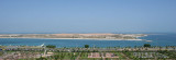
Seaport Authority. Dhow Harbor is approached through a buoyed channel leading N of a detached breakwater, the N end of which is located about 2 miles SW of Mina Zayed harbor entrance. Both the channel and basin are dredged to a depth of 6m.
Municipality Port, with a dredged depth (2008) of 6m and has been constructed within reclaimed land located E of the entrance channel to Dhow Harbor.
Sea Wing Access Channel has been reclaimed and is no longer in use. A power cable, with a vertical clearance of 60m, crosses Khawr al Bighal close SE of its junction with the nowclosed Sea Wing Access Channel.
A bridge to connect Abu Zaby Island and Jazirat as Sadiyat is under construction (2007) across Khawr al Bighal, in approximate position 24°31'20.4''N, 54°24'09.0''E. The dredged channel in this vicinity has been reduced to a width of 115m and is marked by lighted buoy121212s.
No traffic is permitted outside these buoys.
The maximum vertical clearance available due to this construction is 19m, although it should be noted that the following transit limitations have been reported (2009) to be in effect:
1. Maximum allowable air draft within 40m of the centerline at high water—25m.
2. Maximum allowable air draft within 40m of the centerline at low water—26m.
3. All vessels needing to transit under the bridge are required to report their air draft to Mina Zayed Port Control and receive permission prior to passing under the bridge.
2013/02/21
Update
JoBu
Dhow Harbor (Abu Dhabi)
2013:02:21 15:43:32
2013-02-21
Update
JoBu
Share your comments or photos on "Dhow Harbor (Abu Dhabi)"

Sites around Dhow Harbor (Abu Dhabi)

Flying distances - Direct line

Saadiyat island (Abu Dhabi)

3.8nm
67°
Saadiyat Island is a large, low lying island of 27 km², 500 metres off the coast of Abu Dhabi island to be developed.
Saadiyat Island’s Cultural District will house the world’s largest single concentration of premier cultural assets, including the Lord Norman Foster-designed ...
6 Oct 11
Jojo

Yas island (Abu Dhabi)

12nm
97°
Just off Abu Dhabi city, this emerging entertainment destination is within a 30 minute drive of the UAE capital and 50 minutes from Dubai. Here you'll find the fabulous Yas Marina Circuit - the world class motor sports race track which hosts the annual Formula 1ª Etihad Airways ...
6 Oct 11
Jojo

Lulu Island (Abu Dhabi)

1.6nm
239°
Lulu island is  about 4 000 m² man made island  located just in front of Abu Dhabi's corniche. The construction was completed in 1992.
Lulu Island is currently closed to the public, it is only access now being by private boat.It has several basic facilities such as ...
24 Sep 11
Jojo

Al Reem Island (Abu Dhabi)

2.4nm
124°
Al Reem Island, a natural island 600 meters off the northeastern coast of Abu Dhabi island.
It is the first free zones in Abu Dhabi, where foreign nationalities can buy property as leasehold. Reem island will be easily accessible via 9 bridges that will link it to Abu Dhabi, ...
24 Sep 11
Jojo

Mina Zayid (or Zayed) Port (Abu Dhabi)

1.2nm
340°
Mina Zayed [Port Zayed, or Abu Dhabi Port] is the sea port of Abu Dhabi.
Winds—Weather.
The port is open to the shamal, blowing from the N and NW.
Tides—Currents.
Tides here have a maximum spring range of 2m, while the neap range is 0.1m. Tidal currents in the area ...
6 Oct 11
Jojo