Castle Bay, which lies on the SE coast of the island about 2 miles N of Cape Winifred, is deep and clear in its central part.
A rock, awash, lies about 0.3 mile S of Castle Bay Point, the N entrance point of the bay. Foul ground, with depths of less than 9.1m, extends about 0.2 mile S from the rock. A dangerous wreck lies in shoal water about 0.3 mile SSW of Castle Bay Point.
During fair weather, anchorage can be taken, in depths of 25.6 to 27.4m, with Castle Bay Point bearing 062°, distant about 0.5 mile.
Nancowry Island lies close S of and overlaps the S end of Camorta Island. Nancowry Harbor, a secure landlocked inlet, lies between them. The E entrance of Nancowry Harbor lies between the SE end of Camorta Island and the NE end of Nancowry Island. The approach to this entrance leads ...
Chowra Island, which lies about 24 miles SSE of Batti Malv Island, is generally low but rises to a 104.5m high rocky pinnacle at its S end. The island looks like a hat from the offing. Sanenya, the principal village, lies on the NE coast. It has area of 8.2 sq km with a population ...
Trinkat Island, which lies between 1.5 and 2.5 miles E of the S part of Camorta Island, is separated from that island to the W and NW by False Bay and Beresford Channel. Trinkat Island is low, level, and covered by coconut trees. An extensive reef surrounds the island. Morrel Point, ...
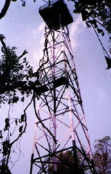
Tillanchang is 15 km long and about 1 km in wide
Island and lies on the Eastern periphery of Indian waters. It is the
Eastern most island in the Nicobar Group of islands. The 30 m high GI trestle tower was erected
expeditiously and the 300 mm equipment with electronic flasher, ...
Bompoka island lies about 1,8 NM east from southern end of nearby Teressa Island in the Nicobar group of islands. The hills on the island rise upto 193 m. The island
has dense forest and some portions have grass growth. There is thick
coconut palm growth on shores all round ...
Beresford Channel is entered from the S through False Bay. Both shores are fronted by reefs and shoals that extend almost 0.8 mile offshore. A number of shoals, with depths of 5.5 to 11m, lie in the middle of the S part of the channel. The channel on both sides of Middle Reef, ...


 Castle Bay, which lies on the SE coast of the island about 2 miles N of Cape Winifred, is deep and clear in its central part.