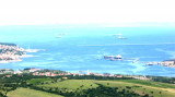
Koperski Zaliv (Baia di Capodistria) is entered between Rt Ronco and Rt Debeli, 5 miles NE.The NE and SW shores of the bay are hilly, but the shore at the head of the bay, through which the Fiume Risano flows, is low. Monte Sermino, surrounded by salt beds, rises isolated in the river ...
The Gulf of Piran or Piran Bay (Slovene: Piranski zaliv, Croatian: Piranski zaljev or Savudrijska vala, Italian: Baia di Pirano) is located in the northern part of the Adriatic Sea, and is a part of the Gulf of Trieste. It is between Rt Madona at N and Rt Saudrija. It was named ...
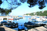
Le petit port de Duino est composé d'un bassin protégé par un quai; il est géré par le cercle Velico di Duino.Dangers: attention aux enrochements submergés qui prolongent sur 20 m le brise-lames du port.Profondeur: de 0,50 à 5 m. 50 pl, dont 5 visit. (<7 / 8 m) Mail: ...
Le port Sistiana se trouve dans une baie naturelle protégé par deux brises-lames; dans la zone E le quai est bétonné et de celui-ci partent quelques pontons flottants utilisés par les plaisanciers. 500 m au SE de Sistiana se trouve le quai de la Cava (50 m) avec deux pontons ...
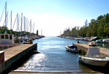
C'est un port-canal artificiel, situé à l'embouchure du fleuve Timavo, son entrée est à environ 350 m au SW du feu du quai de Duino. Il est long d'environ 400 m, large de 50m et orienté NS. A côté du port-canal existent 3 canaux secondaires longs d'environ 320 m et large de ...


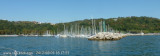
 Anchoring on the East side of the Castle del Duino by 7m depth.
 Mouillage de beau temps à l'Est du chateau le long de la falaise en direction du port de Sistinia. 8m de fond au pied du chateau, bonne tenue.
")
")