Le Cap Nègre, est devenu le lieu de résidence du Chef de l'Etat français (Nicolas Sarkozy). Appartenant à la famille Bruni-Tedeschi depuis 1970, la solide batisse surmontée de deux tours est bâtie sur un promontoir rocheux, au coeur d'une pinède, avec une vue panoramique sur la Méditerranée.
Cap Negre , a dark promontory, terminates in steep cliffs and is surmounted by a prominent house with two towers, which when seen from E, resembles a signal station. A beacon, which is used in connection with a measured distance, stands near the extremity of the cape. Another beacon, having the same use, is situated 0.8 mile NNW of the cape.
Prohibited areas, the limits of which are shown on the chart, lie SW of Pointe du Titan (Ile du Levant) and extend up to 2 miles from the coast. These areas, which are used by French naval vessels, are not in force between July 1 and August 31. Vessels are prohibited from approaching ...
Ile de Porquerolles lies centered 3 miles SE of Ponte de l’Esterel. The summit of the island, located 1 mile from its E end, is 142m high and surmounted by a signal station.
Toulon is a large military harbour on the Mediterranean coast, with a major French naval base.The prevailing winds are from the NW (Mistral) and W. These winds may reach a velocity of Force 11. Winds from the E and SE, which are less frequent, are generally accompanied by rain squalls, ...
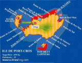
Ile de Port Cros, lies close E of Ile de Bagaud, is mainly wooded and is the highest island of the chain. Its summit, 207m high, is surmounted by a building, with two white cupolas, which are visible from a considerable distance. An islet, 63m high, lie 0.2 mile S of the S extremity ...
Golfe de Giens is entered between Pointe de Carqueiranne and Pointe Escampobariou, 4.7 miles SE. Pointe Escampobariou is the SW extremity of Presqu’ile de Giens, a peninsula, the W side of which is 118m high and surmounted by a tower. The E side of this gulf is bordered by ...


 Le Cap Nègre, est devenu le lieu de résidence du
  Cap Negre , a dark promontory, terminates in steep cliffs and is surmounted by a prominent house with two towers, which when seen from E, resembles a signal station. A beacon, which is used in connection with a measured distance, stands near the extremity of the cape. Another beacon, having the same use, is situated 0.8 mile NNW of the cape.