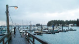
Located north of Monti Bay, the small boat harbor is
operated by the City and Borough of Yakutat. Primarily used by smaller
commercial fishing boats, the harbor facilities consist of six main
floats, a launch ramp and grid. A seaplane float is located at the end
of the ...
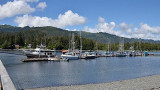
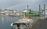
The City and Borough of Sitka Harbor Department operates and maintains
5 boat harbors to include Crescent Harbor, Sealing Cove Harbor, ANB
Harbor, Thomsen Harbor and Eliason Harbor. Phone: 907-747-3439
Fax: 907-747-6278 All transient vessels are required to register with the ...
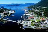
The City of Kodiak is situated on the northeast corner of Kodiak Island
in the Gulf of Alaska, South of Anchorage and east of the Alaska
Peninsula.
Kodiak is proud to offer a full range of dockage, boat yard and
marine services for commercial fishing, cargo, passenger, and ...